Keeping in Touch
Communication technology has come a long way since 1876, when Alexander Graham Bell famously said in the first telephone call “Mr. Watson, come here. I want to see you.”
The first hundred years of telephone history was mostly about land lines connecting homes and business, and then cell phones changed everything. Like many people, I first experienced cell phone connectivity with a Motorola DynaTAC "brick phone" (10 inches tall and 2.5 pounds), and since then phones have gotten so small that you see people walking down the street talking into their wristwatches, like Dick Tracy used to do in 1930s comic books.
Cellular technology is great, but it has its limits. Regardless of which provider you use, you can't get cell coverage in an area that isn't within range of a cell tower, and there are areas where it will probably never be economically feasible to install and maintain a cell tower because there are so few people around to use it.
Those sorts of remote wilderness areas are exactly where we enjoy spending time exploring and hiking. But when I go out for a night in the mountains with one of the dogs, I wouldn't be comfortable having no way to contact the outside world. A simple problem like a sprained ankle could turn into a disaster, and I wouldn't want Megan to spend the night worrying about things like whether or not we made it to our destination.
For the last four years, we've used a Garmin satellite communications device to solve these problems, and we're very pleased with how well it works. This post is about the details of what we use and why we like it.
Satellite communications
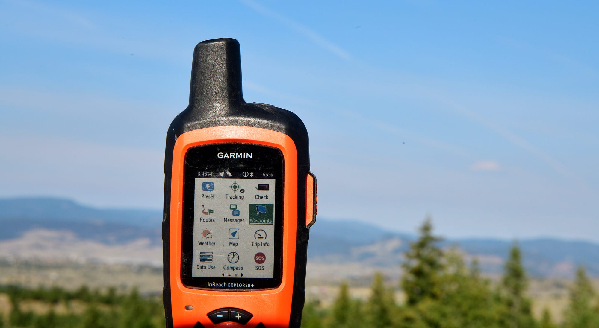
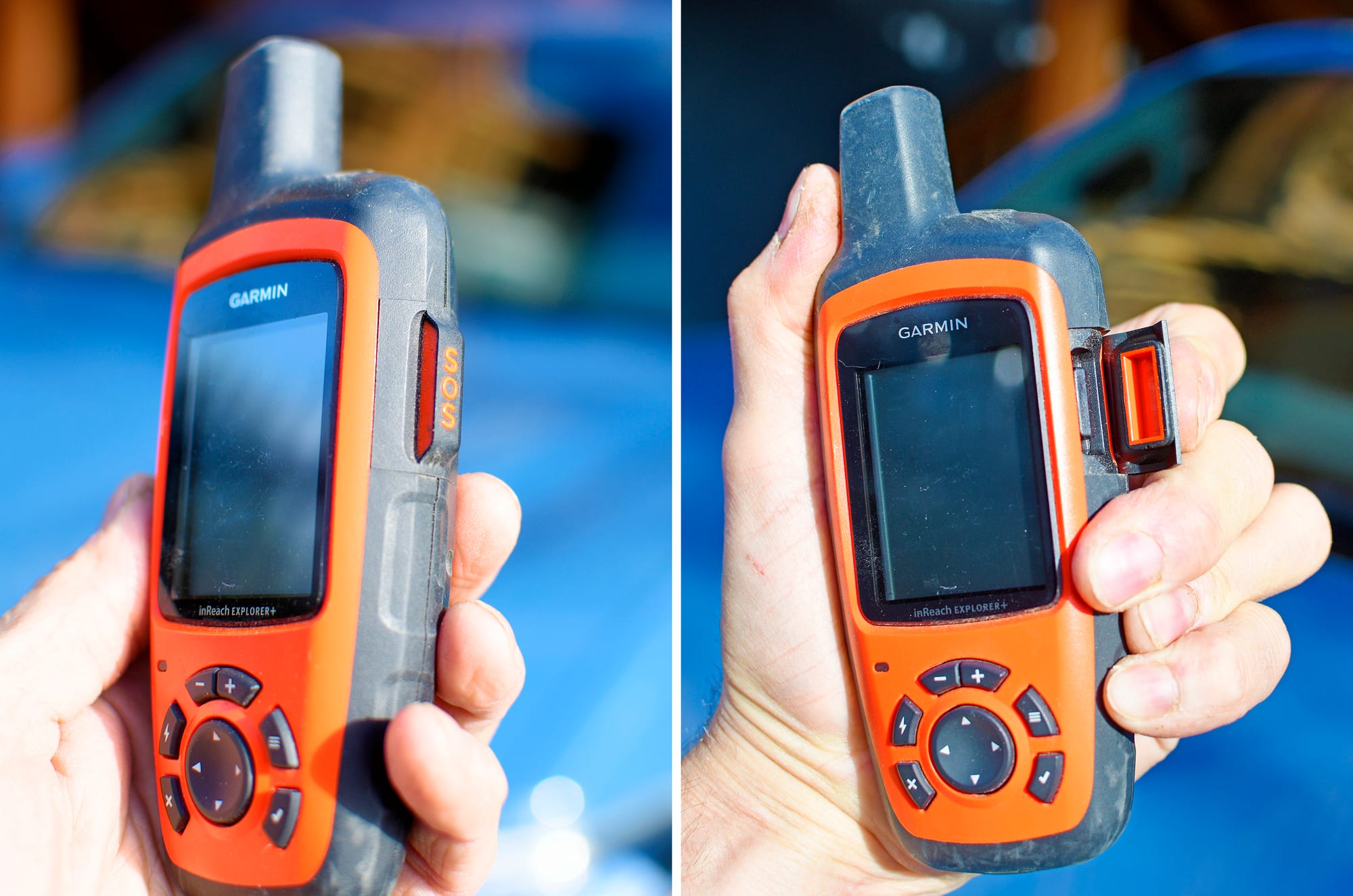
The device that I carry with me at all times in the truck is the Garmin inReach Explorer Plus, a two-way handheld satellite communicator. I bought mine in 2021, and the Explorer Plus model has been discontinued since then, but the device is still fully supported by the Garmin network. As I'll explain below, I'm glad I got the Explorer Plus before they discontinued it, because I like it a little better than the replacement model, the Mini 2.
Here's a quick summary of the features of the Explorer Plus:
- Like all Garmin inReach devices, it use Iridium's satellite constellation, which currently comprises 66 active satellites and 14 in-orbit spares, and provides reliable coverage anywhere on earth.
- You can do standard two-way text messaging from anywhere (satellite subscription required). Texts can be sent to any cell phone, and can include a link that shows your current location on a map.
- All Garmin satellite subscriptions include the SOS feature, which gives you one-button access to rescue services in your area, 24 hours a day, 7 days a week, anywhere on the surface of the earth.
- The device is extremely sturdy – I've dropped it on rocks several times, and it doesn't even have a scratch. It can also be submerged in water for up to 30 minutes without damage (it has an ingress protection rating of IPX7).
- It has a rechargeable lithium ion battery, and impressive battery life. They advertise 100 hours battery life, and based on my experience that seems to be pretty accurate.
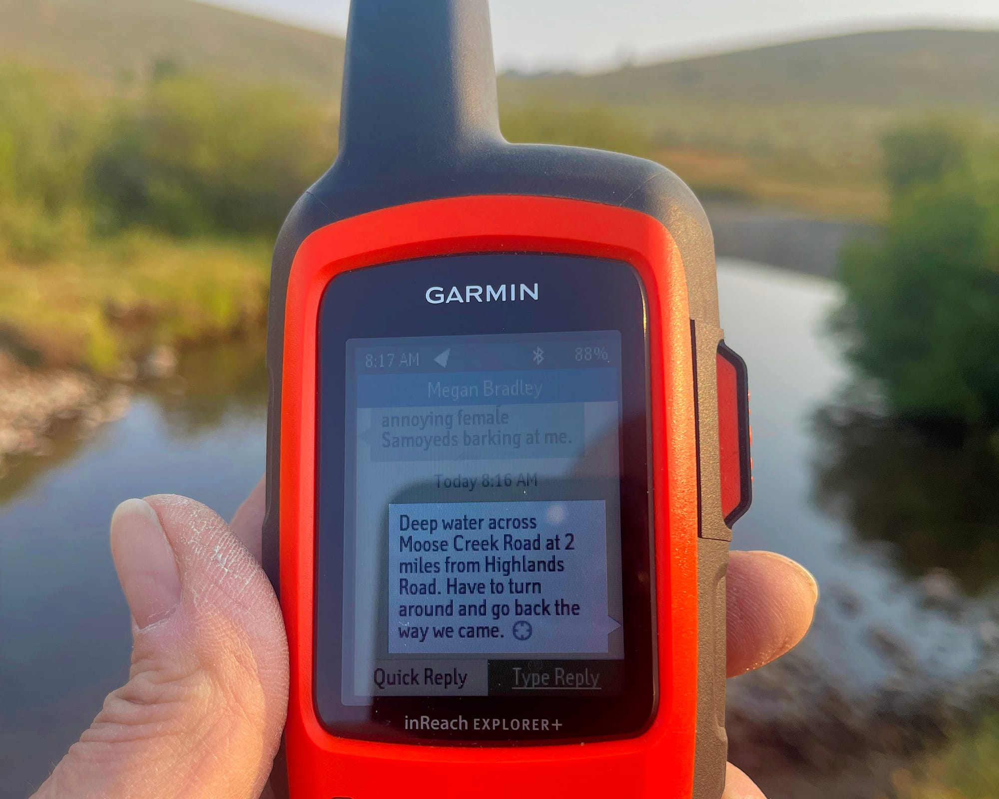
The Explorer Plus doesn't have a keyboard, so "typing" on it is a tedious process that uses one of those interfaces where you select each letter off a grid, one at a time. That would be a pain to use, especially in a stressful situation, but thankfully there's a free Earthmate app that tethers your phone to the device via Bluetooth. With Earthmate, sending a text message from my Garmin is as easy as typing any other message on my iPhone, and I can also quickly select recipients from my Contacts.
The Earthmate app also has some other features that I never use, such as downloadable topographic maps, a digital compass, and altimeter.
Other options
A two-way satellite communicator like the Garmin inReach Explorer Plus isn't the only option for wilderness communications, but it's the best fit for our needs. For lower cost, you can get GPS satellite beacons that only do one-way communication, or only support an SOS function, but we like having the ability to have a two-way conversation with anyone, at any time.
Starting with the iPhone 14, Apple now has an SOS feature, although it's different from Garmin's SOS feature in a few ways.

Apple calls this feature Emergency SOS via Satellite, and it's intended for emergencies only. So you can't, for example, use it to tell a loved one that you've been delayed a few hours but everything's fine. It uses the 25-satellite Globalstar constellation, and is currently only available in a few countries. I don't travel internationally as much as I once did, but I like knowing that my Garmin will work exactly the same anywhere I go.
The Starlink Mini hardware is another option that some people use for wilderness connectivity. Their huge low-altitude satellite network provides great coverage, but Starlink isn't available in most countries, and also isn't available in polar regions. And the Mini has multiple components, making it more complicated to carry and use than a Garmin.
If money were no object, Iridium sells a line of ruggedized satellite phones that are popular with government employees such as the Department of Defense and wilderness explorers, but those are more than we need.
Some Iridium trivia: the first phone call on the Iridium satellite network was in 1998, when US Vice President Al Gore placed a satellitel phone call to Gilbert Grosvenor, the great-grandson of Alexander Graham Bell. Grosvenor was chairman of the National Geographic Society at the time.
Using the Garmin
Garmin supports many different use cases, but our needs are pretty simple. Most of the time, I'm just taking a drive in the mountains with the dogs, and we may park the truck and go for a hike somewhere. I want Megan to be able to check my location at any time, and I want to be able to let her know things like when we leave the vehicle, when we're safely back to the vehicle, and so on.
I usually turn the Garmin on after we leave town, and I have the ActiveTrack feature turned on, so it's uploading my location every few minutes. From that point forward, Megan can go to my MapShare link at share.garmin.com/<MyUniqueIdentifier>, and she'll see a blue triangle marking the last spot where my Garmin has recorded my location, as well as the path I took to get there.
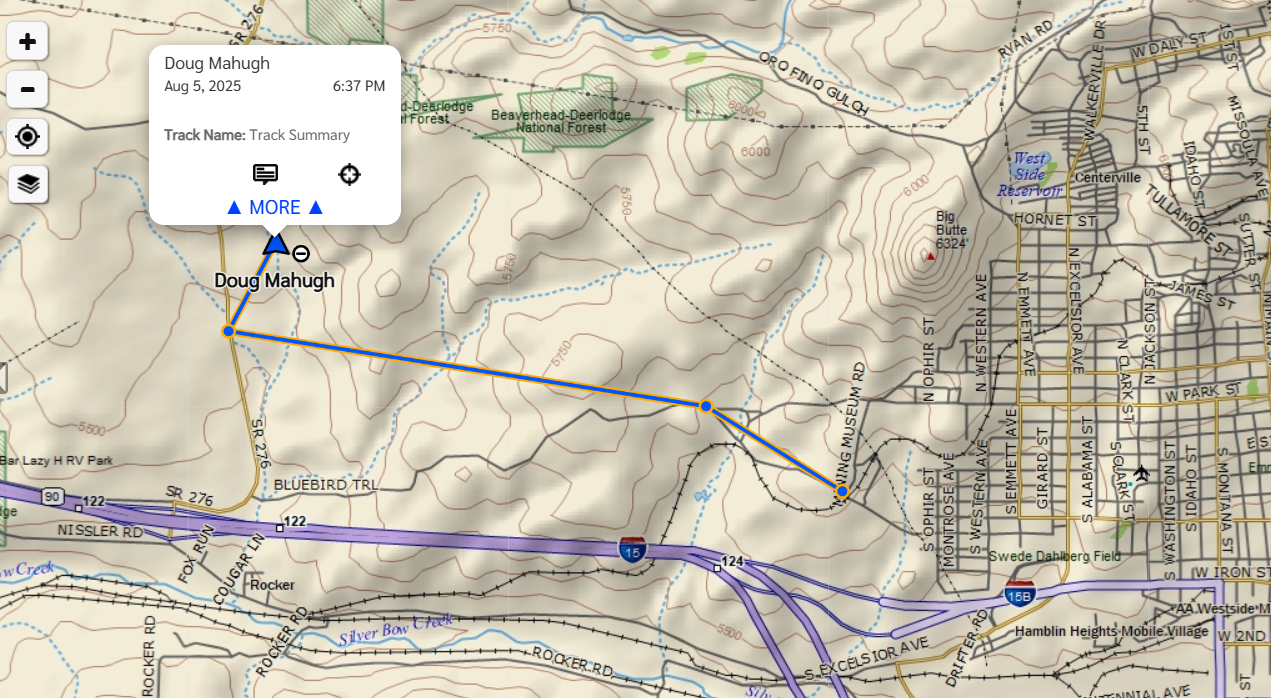
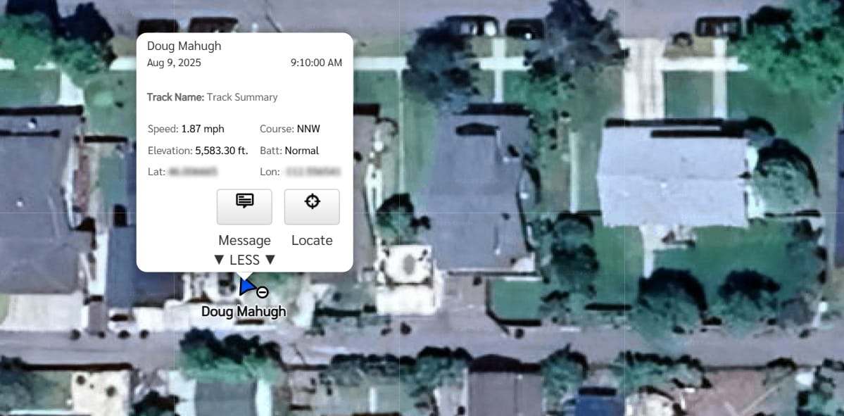
There are a variety of configuration options for the MapShare feature, and there's also an alternative feature called LiveTrack, which I don't use. My goal is just to make it easy for Megan to know where I am when I'm out in wilderness areas, using a process that works exactly the same whether I have cell coverage or not.
One detail applicable to all satellite communications devices is that you need to give the device a clear view of the sky, so that it can find satellites and connect to them. I've found that the small mesh pocket on the side of my backpack works well for this, so that's where I keep the Garmin when I'm hiking.
Worst case scenario
I hope to never use my Garmin to request a wilderness rescue, but that capability is one of the main reasons I carry it. There's great peace of mind in knowing that I can push a button and immediately have emergency responders on the way to my precise location if needed.
Pressing the SOS button sends a message to the GEOS International Emergency Response Coordination Center (IERCC). GEOS is a global emergency response organization that was acquired by Garmin in 2020. When GEOS receives an SOS message, they immediately notify the appropriate emergency response agency (which can be a police department, the Forest Service, a military base, or other agency depending on your location), and they also reach out to your designated emergency contact. They try to get in touch with the person who sent the SOS as well, to ask clarifying questions, but regardless of whether you respond they will stay in touch with all parties to coordinate communications until you're located and have the help you need.
Garmin releases an annual report that summarizes all of the SOS incidents they handle each year. The most recent year for which complete data is available is 2023, when they handled SOS incidents from nearly 100 different countries. You can read the full report here: 2023 Garmin inReach SOS year in review.
For a closeup look at one of those SOS incidents, check out the YouTube video Pushing the SOS Button In The Sawtooth Wilderness, by Jessica "Dixie" Mills. She was hiking alone in Idaho's Sawtooth Wilderness Area when she had a medical emergency due to a heart condition (elevated heart rate, afib, tightness in her chest), so she pressed the SOS button on her Garmin inReach Mini 2. Within 90 minutes, a helicopter with paramedics was at her location, and less than 5 hours after pressing the SOS button in a remote and rugged wilderness area she was in a hospital getting expert care. She recovered completely, and put together a second video with more details about the experience entitled What To Expect When You Hit The SOS Button On The Garmin InReach.
The price of peace of mind
For what you get, I feel like the Garmin SOS service is very reasonably priced. I paid $450 for my Explorer Plus, which has been discontinued, but the inReach Mini 2 that replaced it currently sells for $350.
You also need a Garmin subscription plan, which covers sending and receiving messages and checkins as well as use of the SOS service. I pay $11.95 per month for our subscription, which is roughly equivalent to what they currently call the Essentials Plan, as covered here. For that price, I can send or receive up to 50 free messages per month, and then I pay $.50 for each message beyond the first 50. (I've never actually sent 50 messages in a month.)
The third cost, which I highly recommend, is an insurance plan to cover the cost of a helicopter rescue if that's ever needed. In Dixie's example covered in the YouTube videos linked above, the cost of the helicopter rescue was $60,000, but she had insurance that covered nearly all of it.
As with my discontinued Explorer Plus device, the specific insurance plan I have is no longer offered by Garmin but they still support it. I'm pay $29.95 per year for coverage of up to $50,000 per incident and up to $100,000 per year. Garmin has replaced that plan with what they call the SAR 100 Plan for $39.95 per year. The SAR 100 insurance plan doesn't cover high-risk activities such as BASE jumping or free climbing (rock climbing without ropes), so if you engage in those activities you need the $299 per year SAR High Risk Insurance. And for high-altitude mountain climbing above 5000 meters elevation, they also offer SAR High Altitude Insurance for $999 per year.
Overall, the cost of my Garmin hardware, subscription, and insurance is about the same as buying a Starbucks latte once a week. A great deal for the peace of mind we get from it!